The heat continues for even LONGER, but no record will fall today!
A record high temperature has been recorded for three out of the last four days and we’ll be very close to the record high temperature both on Christmas Day and on Friday too! Temperatures today will be about as warm as they were yesterday, but today’s record high is 91°. That, thankfully, is out of reach! What also may be out of reach, at least through the weekend, is chillier air. A strong cold front is still expected to blast through Sunday, but it’s arrival time has slipped back to Sunday night meaning highs will stay near or above 80° straight through the weekend.
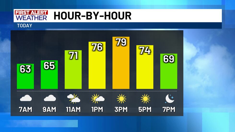
Yesterday’s record high temperature of 82° just barely broke the record of 81°, but a record is a record! Although we were set to tie the record for highest low temperature at 66°, we managed to sink to 63° just 13 minutes before midnight leaving the record intact. Like I mentioned above, today’s record high of 91° is safe, but it’s still going to be another warm day of weather. Be aware that there may be some developing fog hanging around through the mid-morning hours across Central Texas. If your travels take you into East Texas, Southeast Texas, or southward down I-35 past Austin, there will likely be some thick fog through at least the mid-morning hours. High pressure remains overhead, so we’re right back in the upper 70s and lower 80s this afternoon.
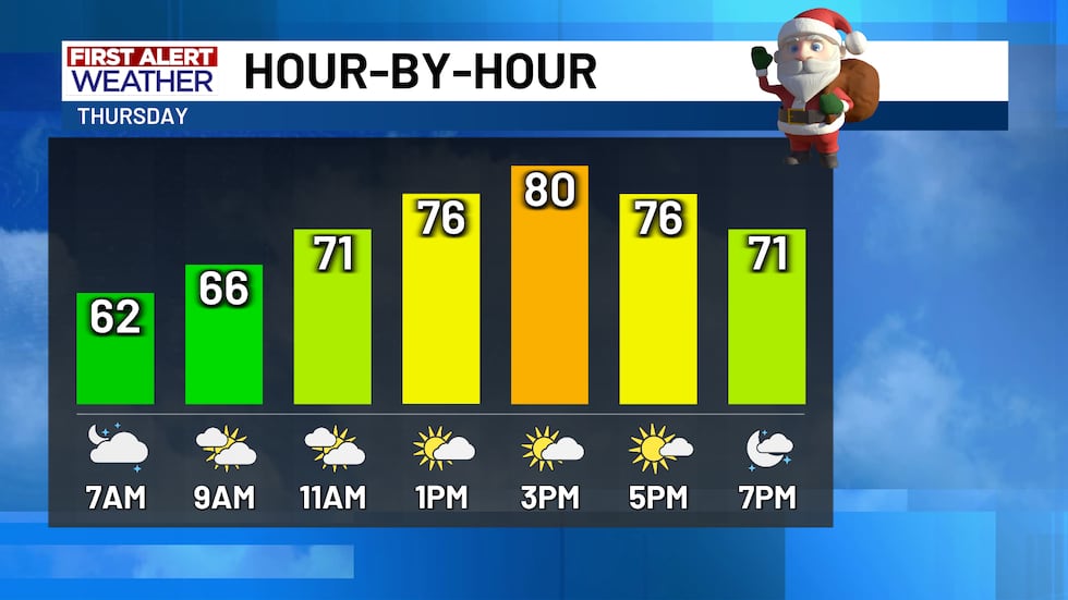
The Christmas Day forecast remains a hot one and the high temperature forecast continues to creep higher! Thursday’s forecast high of 80° may fall just a bit short of the record high of 82°, but it’ll be close! Yet again, morning clouds with temperatures in the low-to-mid 60s will give way to afternoon sunshine, and we’re also expecting a relatively calm south wind today to increase with gusts near 20 MPH tomorrow. Friday’s forecast is coming in a bit hotter too thanks to the return of southwesterly winds in the afternoon. We’re again out the door in the low-to-mid 60s, but highs will settle in the mid-80s as the dry and hot southwesterly wind arrives. Friday’s record high of 84° may fall with our forecast high of 85°.
Our next cold front is still set to push through this weekend, but it’s arrival is now pushed back to Sunday night! The slower arriving front means that the warm temperatures will last all weekend long. It’ll be some whiplash, though, as you may get back inside Sunday afternoon to warm weather and head back outside Monday morning to a chill! Stop me if you’ve heard this before, but morning clouds will give way to afternoon sunshine Saturday with highs in the upper 70s and low 80s. Since Sunday’s front doesn’t arrive until after sunset, highs will yet again top out in the upper 70s and lower 80s Sunday afternoon. It will be a bit cloudier during the day Sunday, but southwest winds ahead of the front should boost temperatures despite less sunshine overhead.
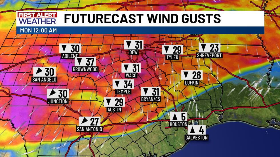
The timing of Sunday’s front continues to go all over the place, so it is NOT yet locked in. However, the latest forecast model data is trending toward the front arriving after sunset. Unfortunately, we’re still not seeing much in the way of rain with the front, but there is still a 20% chance for some light sprinkles or a stray shower Sunday late day into Sunday night. Sunday’s cold front will sharply increase the north winds with gusts as high as 40 MPH Sunday night into Monday morning. If you have any outdoor Christmas decorations, it’s strongly advised that you take advantage of the warm weather this weekend and take them down so they don’t blow away Sunday night! As far as temperatures go, we’ll likely see temperatures drop quickly into the 50s and 60s as the front pushes in with temperatures continuing to tumble through the night and potentially through the day Monday. In fact, our high temperatures Monday may be reached just a bit after midnight! Most of the day Monday will be cloudy, windy, and cold with temperatures in the 40s and wind chills in the 30s.
Copyright 2025 KWTX. All rights reserved.


