First Alert Weather Day: Strong storms expected tonight, another round Saturday afternoon too
The first and only days with high rain chances this October are today and tomorrow as a potent storm system blasts through the Southern Plains. This storm system will bring us two separate rounds of storms and both rounds may feature severe weather. We could also see enough rain for flash flooding in a few spots too. Although both today and tomorrow are First Alert Weather Days, the first severe storm chance likely won’t arrive until after sunset tonight.

Temperatures will only warm up into the mid-80s today with overcast skies throughout the day. As far as daytime rain chances go, we’re not expecting much more than a few scattered light showers off and on this morning and afternoon. Everyone has the opportunity for a few daytime showers, but the main rain location should be for cities and towns near and west of I-35. There’s a chance a few showers may try to strengthen into thunderstorms late this afternoon, but the vast majority of thunderstorms and the severe weather risk arrives after sunset tonight.


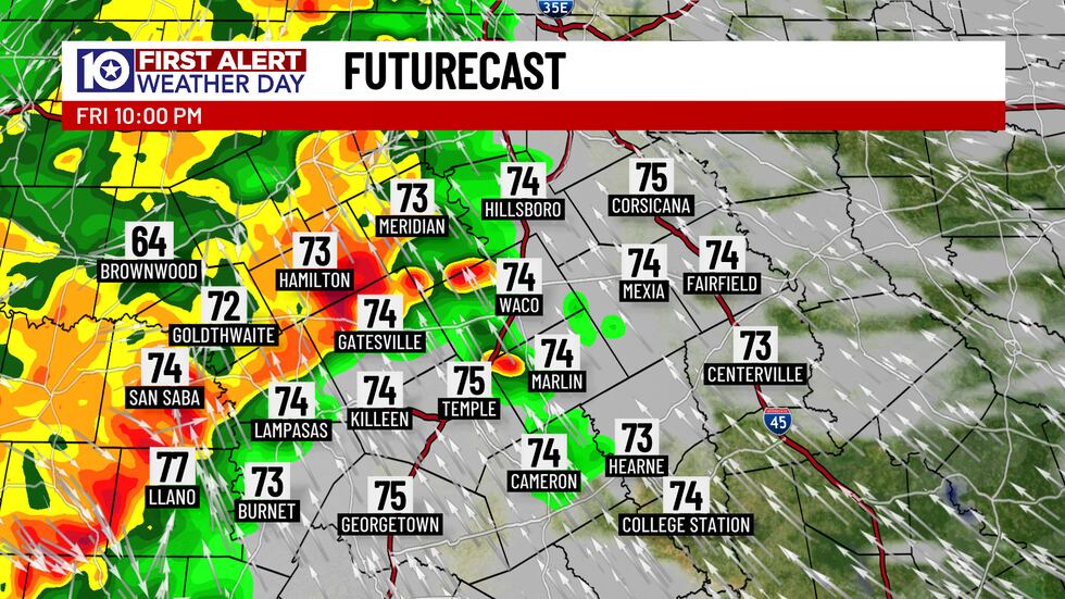

Some Friday night football games may be able to get off without a hitch, but some have already been moved up to avoid tonight’s inclement weather. Cities and towns west of Highway 281 will see storms first, likely arriving near or after 8 PM. The line of storms progressively moves eastward, likely approaching I-35 around or after 10 PM. For cities and towns east of I-35, showers and storms may not actually begin until closer to or after midnight. Like with any line of strong storms, the main severe weather risk stems from strong straight-line wind gusts. There’s also a chance for a bit of hail, likely no larger than quarter-size, with an off chance for a quick spin-up tornado. The leading edge of the overnight line of storms carries the severe weather risk, and those storms will likely slowly weaken through the overnight hours and also push out of the area by around 2 AM. We’ll still contend with rain which comes to a close from west-to-east just before sunrise, but the severe weather risk will be over by 2 AM. Overnight rain chances are near 90%.

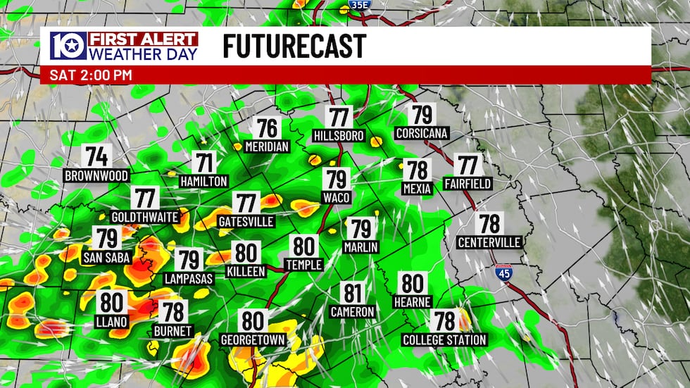


Saturday’s forecast is a bit uncertain, primarily surrounding whether or not we’ll see continued rain during the morning hours. Whether or not we see morning rain will make all the difference for the potential for afternoon strong storms. With the overnight round of rain coming to a close just before sunrise, I’ve dropped rain chances to near 30% through the morning. I’m not confident there will be rain, but there certainly could be with the type of weather pattern we’re in. We’re more likely to see a mostly dry start to the day Saturday, save for a few stray showers, through about midday. After 12 PM, we’re expecting a cluster of showers and storms over the Hill Country to push northward into our area. This cluster of storms may not be terribly strong for the early afternoon hours, but the severe weather risk from them will ramp up as the afternoon progresses. Rain chances are near 70% with the best severe weather chances for cities and towns near and south of Highway 84 and also east of I-35 as well. The strong storm chances will hang around through the early evening hours as the cluster of storms pushes through. We’ll gradually dry out from west-to-east a few hours after sunset with nearly the entire area likely drying out by midnight. By the time the rain comes to a close, we should notch at least an inch of rain for everyone, but there will be spots that could see 2″ to 4″ within the hefty downpours moving through. The highest chances for heavy rain and flash flooding will be near and east of the I-35 corridor.
After Saturday’s storms come to a close, we’re drying out for quite some time. Sunday will for sure be the pick day of the weekend with returning partial sunshine warming us from the upper 50s and lower 60s in the morning into the upper 70s and low 80s late-day. Yes, we’re back on the warming trend as we push into the start of the work week, but another powerful cold front is set to surge through Monday night! This front comes through dry, but it’ll usher in the first true shot of fall air this season! Temperatures will drop into the mid-70s for highs on Tuesday with a secondary push of colder air likely dropping highs into the mid-to-upper 60s with full sunshine both on Wednesday and Thursday! Morning temperatures will also slide into the 40s from Wednesday through at least Saturday. There’s no weather concerns for trick-or-treating Friday night, but it will be a bit on the colder side, so Spider-Man, Ariel, or whoever the kids are dressing up as nowadays might need a jacket. Think of it as a cape!
Stay up to date by downloading our FREE KWTX First Alert Weather App - it will be especially helpful for an overnight storm event like this!
Copyright 2025 KWTX. All rights reserved.


